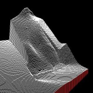
Aerial Lidar (Light Detection and Ranging) is aerial mapping technology that uses calibrated laser returns from the earth’s surface are reflected to an overflying GPS-monitored aircraft equipped with on-board positional and IMU sensors. After post-flight production processes, the acquired Lidar Map data determines the precise elevation and geospatial location of features on the earth’s surface. With innovations such as multiple intensity returns and increased pulse repetition rates, Lidar data is an accurate and effective method for creating three-dimensional topographical aerial maps and highly accurate aerial surveys of both surface terrain elements and man-made structures. Many analytical products can be created form Lidar data. Geo-Cart LiDAR Mapping includes use of Matrice 300 RTK drones which can be fitted with ZENMUSE L1 LIDAR,ZENMUSE X3 RGB SENSOR and ZENMUSE X3 NIR SENSOR capable of producing high density point cloud data for corridor,urban,flood plain or general purpose lidar data.
Ngara Aerial 3D photograph
Do You Have Any Questions?
You’d like to talk to us about a project, or anything else, we’d love to hear from you.